Day 0 - Friday
After our first trip to Starlights in August last year, I have been eager to investigate the track past the most Westerly point that we made it to. The track from here heads north and is a key part of the Mittagong to Katoomba trail.
So in June 2008, Richard and I headed back out to the park and into the valley.
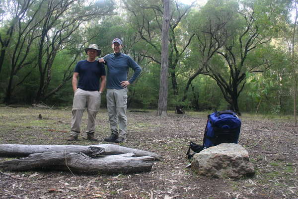
As before, the first nights accommodation was at the head of the park. As we were now in winter, the darkness arrives quite early so we got to camp at 4:00pm. Amazingly, nobody had camped here prior to our trip last year, even the pile of fire wood we left was still there!
Day 1 - Saturday
We took it easy on Saturday morning, there was no rush as the track to the bottom of the valley is not a long one. The day was shaping up well with clear blue sky and very mild conditions. We had the campsite cleaned up by 9:30 and we were on the trail shortly after.
The fire trail section of the track before the head of the Starlights trail was a lot steeper and longer than I remembered! But it wasn’t long before we were both happy to hit the downhill section starting from Point Hill.
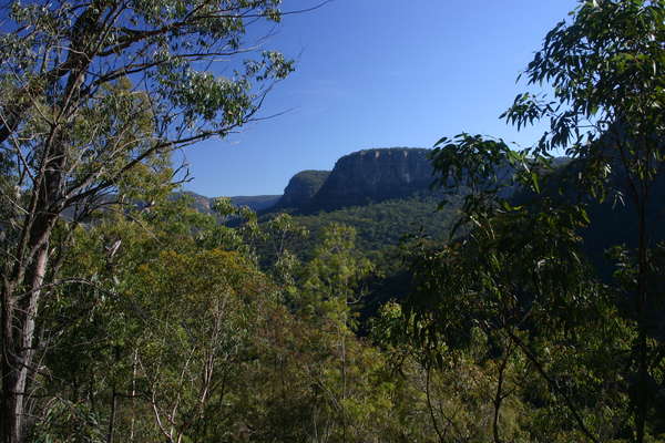
We arrived at the bottom of the valley at 11:30. The place was empty as usual, but looked amazing and green! There was more water in the river here than last time too, so we hung around the valley floor for our morning tea, before heading west along the marked trail.
We made our first navigational error just after the homestead ruin. We managed to get about 20 meters off the track, and from there we couldn’t see any markers, or any foot pads. We eventually found our way back to the track though and didn’t waste too much time. Our second mistake was at “Balloon Tree” where we failed to cross the river here and then found additional markers on the northern side of the river. They led us on a meandering trail until we were blocked by a small gully.
Eventually we made it to the Wanganderry creek and Nattai river junction for a well earner rest. The day was still beautiful, and we enjoyed a leisurely rest right on the river junction from 1:30pm.
After lunch, we decided it was possible to aim for Round Flat by the end of the day. So we headed away from the river, up the cliff face to the west of the junction. Once again, the markers here were very clear, and so we had no trouble finding our way along the first sections of the track. About 400m along the track there was a really good camp site that we marked on the map, thinking we may be back here later!
Shortly after the great campsite, we started to struggle! There was a river crossing here, to get back onto the eastern side of the Nattai, but it was not well marked. The track does terminate at the river, so by process of elimination, we pushed our way across. As soon as we got to the other side, the markers started up again!
We continued along the track which was reasonably well marked, but was also getting quite overgrown. We pushed on though, looking for Round Flat and also a campsite for the night. We eventually terminated the hunt at around 3:15pm, which gave us enough time to return to the great campsite we passed through after lunch before it got too dark. We made it back there by 4:00pm, and had the site set up and sitting in front of the fire very soon after.
The night was very mild again, no frost, rain or wind!
Day 2 - Sunday
I was up at 7:00am and sorted out the water for the morning, and cleaned up the camp. We eventually cleared out a little after 9:30am. Today was going to be a pretty casual one anyway so we were in no rush.
We got back to Emmett’s flat around 11:00am where we had a lengthy morning tea, before heading up the Starlights trail again.
And yes, it was just as steep heading out of the valley as I remember!
We didn’t vary from the trail at all, and made it back to the car around 3:00pm.
Photos
![<div style='float: right;'>[2008:06:01 09:03:01] [20080530-Nattai001.JPG]</div>](../CACHE/LARGE/Large-20080530Starlights20080530-Nattai001.JPG.jpg)
![<div style='float: right;'>[2008:06:01 09:15:48] [20080530-Nattai004.JPG]</div>](../CACHE/LARGE/Large-20080530Starlights20080530-Nattai004.JPG.jpg)
![<div style='float: right;'>[2008:06:01 09:26:43] [20080530-Nattai005.JPG]</div>](../CACHE/LARGE/Large-20080530Starlights20080530-Nattai005.JPG.jpg)
![<div style='float: right;'>[2008:06:01 11:32:19] [20080530-Nattai014_edited-1.JPG]</div>](../CACHE/LARGE/Large-20080530Starlights20080530-Nattai014_edited-1.JPG.jpg)
![<div style='float: right;'>[2008:06:01 12:00:11] [20080530-Nattai018.JPG]</div>](../CACHE/LARGE/Large-20080530Starlights20080530-Nattai018.JPG.jpg)
![<div style='float: right;'>[2008:05:31 09:21:34] [20080530-Nattai019.JPG]</div>](../CACHE/LARGE/Large-20080530Starlights20080530-Nattai019.JPG.jpg)
![<div style='float: right;'>[2008:05:31 09:59:05] [20080530-Nattai025.JPG]</div>](../CACHE/LARGE/Large-20080530Starlights20080530-Nattai025.JPG.jpg)
![<div style='float: right;'>[2008:05:31 10:08:30] [20080530-Nattai028.JPG]</div>](../CACHE/LARGE/Large-20080530Starlights20080530-Nattai028.JPG.jpg)
![<div style='float: right;'>[2008:05:31 10:38:53] [20080530-Nattai029.JPG]</div>](../CACHE/LARGE/Large-20080530Starlights20080530-Nattai029.JPG.jpg)
![<div style='float: right;'>[2008:05:31 11:06:02] [20080530-Nattai046.JPG]</div>](../CACHE/LARGE/Large-20080530Starlights20080530-Nattai046.JPG.jpg)
![<div style='float: right;'>[2008:05:31 11:25:53] [20080530-Nattai056.JPG]</div>](../CACHE/LARGE/Large-20080530Starlights20080530-Nattai056.JPG.jpg)
![<div style='float: right;'>[2008:05:31 11:34:51] [20080530-Nattai059.JPG]</div>](../CACHE/LARGE/Large-20080530Starlights20080530-Nattai059.JPG.jpg)
![<div style='float: right;'>[2008:05:31 11:58:23] [20080530-Nattai065.JPG]</div>](../CACHE/LARGE/Large-20080530Starlights20080530-Nattai065.JPG.jpg)
![<div style='float: right;'>[2008:05:31 12:28:09] [20080530-Nattai067.JPG]</div>](../CACHE/LARGE/Large-20080530Starlights20080530-Nattai067.JPG.jpg)
![<div style='float: right;'>[2008:05:31 13:57:27] [20080530-Nattai096.JPG]</div>](../CACHE/LARGE/Large-20080530Starlights20080530-Nattai096.JPG.jpg)
![<div style='float: right;'>[2008:05:31 14:51:49] [20080530-Nattai098.JPG]</div>](../CACHE/LARGE/Large-20080530Starlights20080530-Nattai098.JPG.jpg)
![<div style='float: right;'>[2008:05:31 16:08:04] [20080530-Nattai105.JPG]</div>](../CACHE/LARGE/Large-20080530Starlights20080530-Nattai105.JPG.jpg)
![<div style='float: right;'>[2008:05:31 16:43:10] [20080530-Nattai118.JPG]</div>](../CACHE/LARGE/Large-20080530Starlights20080530-Nattai118.JPG.jpg)
Google Maps
- gps
