2007 Kosciuszko - Solo hiking in Jagungal wilderness
| summary: | I have been to Kosciuszko plenty of times, but never alone. This trip takes in the wild side of Jagungal on a solo adventure. |
| date: | 24 November 2007 |
| region: | Kosciuszko National Park |
| who: | Graham |
| duration: | 3 days |
| tags: | HIKE - REPORT - KOSI - SOLO - 2007 |
| views: | 1258 |
After many trips with my friends to Kosi and other wonderful locations, I finally managed to organize my first Solo adventure!! The destination was obvious, back to Kosciuszko and the Jagungal wilderness. I’ve walked this area a number of times, and had recently scouted out a couple of areas which I’d like to see, highest on the list was the Jagungal saddle area.
Day 0 - Thursday
I left the office 4:00pm with the weather not looking too promising, but I thought I’d continue on anyway. I went via Queenbeyan and cooma and the rain didn’t stop the entire trip. And I was even driving at 60km/h at times because the visibility was almost zero!! Anyway, I arrived at Round Mountain trail head at 10:15 pm and the rain had reduced to a mere sprinkle. I was energized by this so I packed up and headed down the trail.
I walked straight past Round Mountain hut, as there were five tents pitched here! Everyone was obviously tucked in for the night as there was no activity or light anywhere, which was not surprising at 11:30 pm!! So I pushed on for another 1/2 km or so until I found a nice spot to pitch camp. The rain had almost stopped now, so I was expecting tomorrow to work out just fine!
Day 1 - FRIDAY
The rain had stopped by the time I had finished packing up camp. And I was able to set off by 8:00am. My target today was to try and reach the northern most Bulls Peak, which was almost 20kms as the crow flies!!

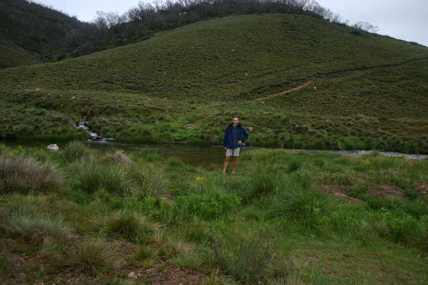
The Tumut was high and cold as always, but this time I brought some thongs to walk across the rocky river bed, that made things so much easier!! Then the hard slog up Farm Ridge began!! I was buggered by the time I got to the top of the ridge, so a quick stop for morning tea and admire the very small slither of blue sky in the distance.
At the bottom of Farm Ridge trail, I was hit by the flies. The ruins at the bottom of the trail must attract them as the area sees a lot of campers. Continuing along the trail, I went over Bogong creek without being eaten by the ants!
I turned off the main trail at O’Keefe’s hut and headed up through the bush to the Eastern side of Jagungal heading for Jagungal saddle. I’d already walked 12km, and the saddle looked like another 5km before stopping for lunch…I must be crazy!
The landscape through here is amazing, although I stayed a little to high in the valley for most of the walk, so in future I need to remember to drop down in the valley early. But getting to the top of the saddle was a major achievement at 1:30pm!!
I had a long lunch, as I needed to recuperate. My target for the day was only a few more km’s along the saddle. A little more altitude was still required, but the weather was not look too bad now, and in fact was improving by the minute.
I climbed through McAlisters saddle which provided great views in either direction, and then I hit the last climb before the end of the day. I could see the Toolong range from here which was the track we followed last time we were here. There were some great views of The Big J from here to the north.
I got to my final destination around 4:00 pm, which was a short distance from the North Bulls Peak. There was a scientific collection station here, what it was collecting was not obvious, but it was pretty cool to look at. There was lots of little campsites around here, and also to the East towards the North Bulls saddle. I found a spot which overlooked all of tomorrow’s targeted peaks. I could see the three Bulls Peaks, Mailbox, Cup and Saucer and Tarn Bluff. And now the weather was perfect!!
Lucky for me, the sun was not setting until 8:00pm out here, so I had a couple of hours to collect fire wood, water and then relax with a Cigar and Whiskey while the sun set in the west.
Day 2 - SUNDAY
After falling asleep at the fire last night, I dragged myself off to bed very early. The morning was very early, as the sun was already beating down on the tent. I could see outside the weather was looking fantastic! No more cloudy skies, the day was clear, and apparently windless.
I left the damp tent to dry out in the sun while I made breakfast and packed everything else up. The beauty of being alone meant that I could get things done nice a quick, so I was able to break camp before 8:30 in the morning. Today the challenge was to hit the 8 peaks of the bulls area, it’s a big challenge but I know I am up to it!
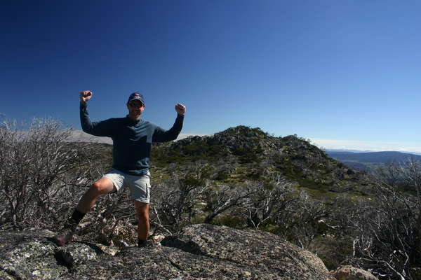
I dropped into the valley to the south and then along the ridge line to North Bulls Peak. Unfortunately, the peak was a little too rugged for me to ascent by myself, so I took a few photos and then moved on to Bulls Peak. Once there, I got some amazing views all around, including of the dozens of crow’s that had been circling all morning!!
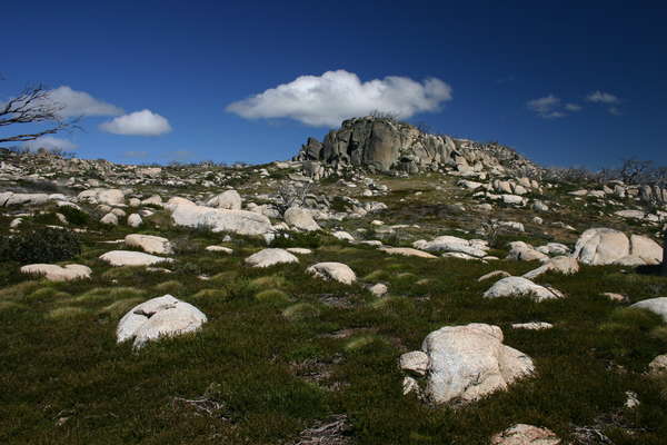
There was an old fire trail up here too which I followed around a while off to the South Bulls Peak. There are also a number of useful little campsites up here with heaps of fire resources, but not a lot of water. From here I traversed past South Bulls and across the saddle to the west and on to Mailbox hill.
Mailbox was amazing, very rugged and very flat at the top. I had become snake paranoid at this stage though as the sun was beating down, and I’d already spotted two snakes slithering away from me. I reached the top of Mailbox and hung around for a few minutes before moving on to Cup and Saucer.
Once again the views were amazing from here, but I got to what I thought was the top of the Cup, and realized that everything was too rugged here for me too. So I headed off quickly towards the evasive Tarn Bluff. The walk was mostly down hill to start with and I ended up on the amazing saddle with a great little creek running in all directions. Once I climbed out of the saddle, I got disoriented for a while until I managed to get my bearings again and dropped down towards the Geehi River Lake.
I was not too sure what to expect when I got to the lake, but this place was amazing!! The lake was much bigger and deeper than I was expecting, and full of bird life….until I arrived!! There was also some great rapids here and some huge rocks. I didn’t need to take the boots off to cross though, so I pushed on up the other side of the river and towards Strawberry hill.


I walked up the centre of the valley, through the bog to the bottom of Strawberry hill, before sinking into the bog and twisting my ankle!! I sat for a while and thought about what might happen if I broke a leg here….nothing….I’m too good to be caught out by mother nature!! So I picked myself up and walked up the hill to the spot I had previously identified as night two’s camp site…it was lunch time!
The flies were pretty bad, so I ate quickly, strapped my ankle, and the headed off again. I decided I would try and get out to Dershko’s by the end of the day to make tomorrow’s walk a little easier.
I got to Grey Mare fire trail at 3:00pm, after walking along the overgrown Strumbo Hill fire trail. It is a little hard to find, but I’ve taken some good GPS waypoints now, so it should be much easier next time. I had thunder rolling around me for most of the walk so far after lunch, and once I hit Grey Mare, the sky started to darken further.
I had just a few spots of rain on me before I got the wet weather gear out, and then the heavens opened!! The rain was incredibly heavy (like always out here)! But I pushed on as I wanted to get to Dershko’s to dry off. I decided to take a short break at the top of one of the small hills, in the trees but just as I got there a bolt of lightning hit a tree not 100m from me which nearly knocked me off my feet!! So guess what, I started to run down hill!!
I got to Dershko’s a little after 4:00pm, with the rain easing considerably. I hung around here for an hour while the rain stopped and I dried out and warmed up. I had decided to push even closer to the car park before ending my days walk, so I managed to walk another 5kms before ending the day. This meant I had another 22km day of walking today!!
I picked a camp site just off the main trail up in a small stand of trees. My camp was fine and I sat back with a small fire and watched the sun set again. While the sun was setting, I saw this huge storm form above me. The clouds were spinning just like on a weather map and the lightning was flashing 15km over head! It was an amazing site, and would have been very cool if I wasn’t so worried about mother nature having another crack at me once I went to bed!! Fortunately after an hour or so, the clouds abated and I started to relax again.
Day 3 - SUNDAY
I was up early and sat back and watched the sun rise above the hills behind my camp in the morning. My body was exhausted, and the ankle a little sore. But I slowly packed up and headed off by 8:00am. There was only 10km to do this morning before getting to the car, but I know how many hills there were!
I managed to hit the first river crossing by 9:00am, and then on to the bottom of Round Mountain at 10:00am in preparation for the big hill climb out of here!
I slowly moved up the hill towards Round Mountain car park which I finally arrived at by 11:00am. Total trip distance was now 56.6km, a mighty effort for my first solo trip!
![<div style='float: right;'>[2007:11:25 07:43:34] [20071125-SoloHiking010.JPG]</div>](../CACHE/THUMB/Thumb-20071124KOSI20071125-SoloHiking010.JPG.jpg)
![<div style='float: right;'>[2007:11:25 09:51:47] [20071125-SoloHiking021.JPG]</div>](../CACHE/THUMB/Thumb-20071124KOSI20071125-SoloHiking021.JPG.jpg)
![<div style='float: right;'>[2007:11:24 07:51:04] [20071125-SoloHiking047.JPG]</div>](../CACHE/THUMB/Thumb-20071124KOSI20071125-SoloHiking047.JPG.jpg)
![<div style='float: right;'>[2007:11:24 08:53:44] [20071125-SoloHiking070.JPG]</div>](../CACHE/THUMB/Thumb-20071124KOSI20071125-SoloHiking070.JPG.jpg)
![<div style='float: right;'>[2007:11:24 08:55:03] [20071125-SoloHiking074.JPG]</div>](../CACHE/THUMB/Thumb-20071124KOSI20071125-SoloHiking074.JPG.jpg)
![<div style='float: right;'>[2007:11:24 09:35:20] [20071125-SoloHiking078.JPG]</div>](../CACHE/THUMB/Thumb-20071124KOSI20071125-SoloHiking078.JPG.jpg)
![<div style='float: right;'>[2007:11:24 09:54:37] [20071125-SoloHiking085.JPG]</div>](../CACHE/THUMB/Thumb-20071124KOSI20071125-SoloHiking085.JPG.jpg)
![<div style='float: right;'>[2007:11:24 10:25:59] [20071125-SoloHiking089.JPG]</div>](../CACHE/THUMB/Thumb-20071124KOSI20071125-SoloHiking089.JPG.jpg)
![<div style='float: right;'>[2007:11:24 11:07:07] [20071125-SoloHiking098.JPG]</div>](../CACHE/THUMB/Thumb-20071124KOSI20071125-SoloHiking098.JPG.jpg)
![<div style='float: right;'>[2007:11:24 12:05:38] [20071125-SoloHiking125.JPG]</div>](../CACHE/THUMB/Thumb-20071124KOSI20071125-SoloHiking125.JPG.jpg)
![<div style='float: right;'>[2007:11:24 12:56:54] [20071125-SoloHiking135.JPG]</div>](../CACHE/THUMB/Thumb-20071124KOSI20071125-SoloHiking135.JPG.jpg)
![<div style='float: right;'>[2007:11:24 18:28:34] [20071125-SoloHiking159.JPG]</div>](../CACHE/THUMB/Thumb-20071124KOSI20071125-SoloHiking159.JPG.jpg)
![<div style='float: right;'>[2007:11:24 18:28:51] [20071125-SoloHiking162.JPG]</div>](../CACHE/THUMB/Thumb-20071124KOSI20071125-SoloHiking162.JPG.jpg)
![<div style='float: right;'>[2007:11:24 19:16:21] [20071125-SoloHiking167.JPG]</div>](../CACHE/THUMB/Thumb-20071124KOSI20071125-SoloHiking167.JPG.jpg)
![<div style='float: right;'>[2007:11:23 07:41:27] [20071125-SoloHiking189.JPG]</div>](../CACHE/THUMB/Thumb-20071124KOSI20071125-SoloHiking189.JPG.jpg)
![<div style='float: right;'>[2007:11:23 07:53:37] [20071125-SoloHiking195.JPG]</div>](../CACHE/THUMB/Thumb-20071124KOSI20071125-SoloHiking195.JPG.jpg)
![<div style='float: right;'>[2007:11:23 10:16:43] [20071125-SoloHiking202.JPG]</div>](../CACHE/THUMB/Thumb-20071124KOSI20071125-SoloHiking202.JPG.jpg)
![<div style='float: right;'>[2007:11:23 11:17:11] [20071125-SoloHiking207.JPG]</div>](../CACHE/THUMB/Thumb-20071124KOSI20071125-SoloHiking207.JPG.jpg)
![<div style='float: right;'>[2007:11:23 14:25:21] [20071125-SoloHiking227.JPG]</div>](../CACHE/THUMB/Thumb-20071124KOSI20071125-SoloHiking227.JPG.jpg)
![<div style='float: right;'>[2007:11:23 15:54:48] [20071125-SoloHiking255.JPG]</div>](../CACHE/THUMB/Thumb-20071124KOSI20071125-SoloHiking255.JPG.jpg)
![<div style='float: right;'>[2007:11:23 16:48:27] [20071125-SoloHiking261.JPG]</div>](../CACHE/THUMB/Thumb-20071124KOSI20071125-SoloHiking261.JPG.jpg)
![<div style='float: right;'>[2007:11:23 16:59:50] [20071125-SoloHiking262.JPG]</div>](../CACHE/THUMB/Thumb-20071124KOSI20071125-SoloHiking262.JPG.jpg)
![<div style='float: right;'>[2007:11:23 19:17:48] [20071125-SoloHiking273.JPG]</div>](../CACHE/THUMB/Thumb-20071124KOSI20071125-SoloHiking273.JPG.jpg)
